Latest Research
This is the page devoted to our most recent research, from field activities to publication of scientific papers
02/03/2026 – The project SeaWatch just started!
The activities of the project ‘Transforming fishing vessels into stewards of marine biodiversity’ (SeaWatch) have officially begun.
You can find out more and keep up to date via the dedicated page on this website.
04/18/2025 – New paper: Exploring spatial-based management scenarios to protect the seafloor in different areas of the Mediterranean Sea

In recent years, European policies aimed to regulate bottom trawling activities, given the significant environmental damage they cause. Trawling represents a considerable source of income for the economies of many Mediterranean countries.Therefore, it is essential that management measures, including spatial closures, consider the potential long-term consequences of their implementation. This study investigated the impact of different spatial management scenarios on reducing the environmental footprint of bottom otter trawling in four distinct sectors (Western, Southern, Adriatic, and Ionian) of the Mediterranean Sea. Using vessel monitoring systems and logbook data, the study identified core fishing grounds and modelled the effects of various spatial restrictions, including depth-based fishing bans and fishery-restricted areas (FRAs). The results indicate that in all the sectors, the adoption of FRAs does not lead to significant variations in the economic performance of fleets, and the application of the ban over 800 m would allow the protection of a significant portion of the deep-sea bottom with relatively little economic impact. On the contrary, other spatial-based measures lead to different, sector-specific effects. In fact, restricting shallow coastal areas (<6 nm) significantly affects the profitability by reallocating effort to other fishing grounds, with noticeable differences between fleets operating in the same sector (i.e. the Adriatic Sea); meanwhile, bans over 600 or 700 m would determine very different economic effects in the four sectors. Overall, these results suggest that a sole fishery management measure approach is inadequate. Tailored region-specific measures are instead essential to balance ecological sustainability and economic outcomes across different Mediterranean regions.
04/18/2025 – New paper: The effect of marine litter on fishery economic performance

Seabed plastic pollution seriously threatens marine biodiversity and ecosystem functioning by damaging marine organisms and disrupting ecosystems. Litter accumulation zones may overlap with fishing grounds for commercially important species, reducing productivity and yield. As studies have yet to be conducted on this topic, there is an urgent need to fill the knowledge gap on the impact of plastic pollution on fisheries and stock management. For these reasons, this study aimed to analyse the effect of seafloor plastic on fishing economic performance (as revenues) and commercially important species by mapping trawl areas and identifying litter hotspots on the seafloor. A model based on landing and Vessel Monitoring System data was employed to estimate the fishing grounds of the species, and a random forest machine-learning technique was used to identify seafloor litter hotspots. The findings demonstrate that seafloor plastic hotspots overlap with the fishing grounds, thus hurting economic productivity. The implications of this problem pose a significant threat to exposure and impact on certain species. Our findings indicate that seabed plastic pollution should be recognised as affecting fisheries administration and conservation approaches.
11/14/2024 – New paper: Shedding light on trawl fishing activity in the Mediterranean Sea with remote sensing data
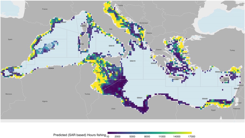
This study uses Synthetic Aperture Radar (SAR) vessel detections and Automatic Identification System (AIS) to predict trawl fishing intensity and distribution of fishing activity in areas where public AIS data are not available. By processing SAR data, considering spatial and temporal autocorrelation, and building a General Additive Model, a statistical relationship between SAR vessel detections and AIS fishing activity was established. The study provides spatially explicit estimates of trawler fishing activity, compared with official fleet records published by the General Fisheries Commission of the Mediterranean, revealing the distribution and intensity of trawl fishing activity not previously publicly tracked. Fishing grounds in the Strait of Sicily along the coast of Tunisia and North of Egypt showed an intensity of trawl fishing activity similar to the Adriatic Sea. This area is historically known to be subject to the highest trawling pressure in the Mediterranean, and also as one of the most heavily trawled regions in the world. The study shows that the integration of remote sensing data, such as SAR, offers a promising avenue to overcome data gaps and improve fisheries management in the Mediterranean where only a portion of the fishing fleet is publicly tracked.
11/10/2024 – New paper: Assessing the overlap between fishing and chondrichthyans exposes high-risk areas for bycatch of threatened species
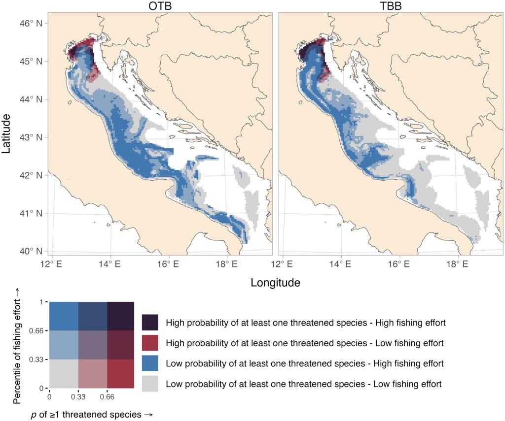
Chondrichthyans (sharks, rays, skates, and chimaeras) make up one of the oldest and most ecologically diverse vertebrate groups, yet they face severe threats from fishing, necessitating improved management strategies. To effectively manage these species, we need to understand their spatial interactions with fisheries. However, this understanding is often challenged by limited data on chondrichthyan catches and species identification. In such cases, assessing potential risks from fishing activities can provide valuable insights into these spatial interactions. Here, we propose a method combining geostatistical models fitted to a fishery-independent dataset with vessel monitoring system (VMS) data to estimate the spatial overlap between chondrichthyans and fishing. Our case study focuses on the western Adriatic Sea in the Mediterranean, examining the overlap between bottom trawling (including otter bottom trawling and beam trawling) and demersal chondrichthyans. We find that the northwestern part of the basin is a hotspot where threatened chondrichthyans (classified as Vulnerable, Endangered, or Critically Endangered by the International Union for Conservation of Nature Red List) greatly overlap with bottom trawling activities. Moreover, some areas, such as the northernmost part of the Adriatic and the “area dei fondi sporchi” in the north-central offshore part, exhibit minimal overlap between threatened chondrichthyans and bottom trawling, potentially serving as refuges. We recommend prioritizing the management of otter bottom trawling in the northwestern basin to protect these threatened species, while also paying attention to the possible impacts of beam trawling on skates and chondrichthyan habitats. Despite certain limitations, our findings demonstrate that combining geostatistical models of species distributions with VMS data is a promising method for identifying areas of concern for species vulnerable to fishing. This approach can inform targeted management measures and cost-effective onboard monitoring programs.
09/10/2024 – New paper: Harnessing AI to map global fishing vessel activity
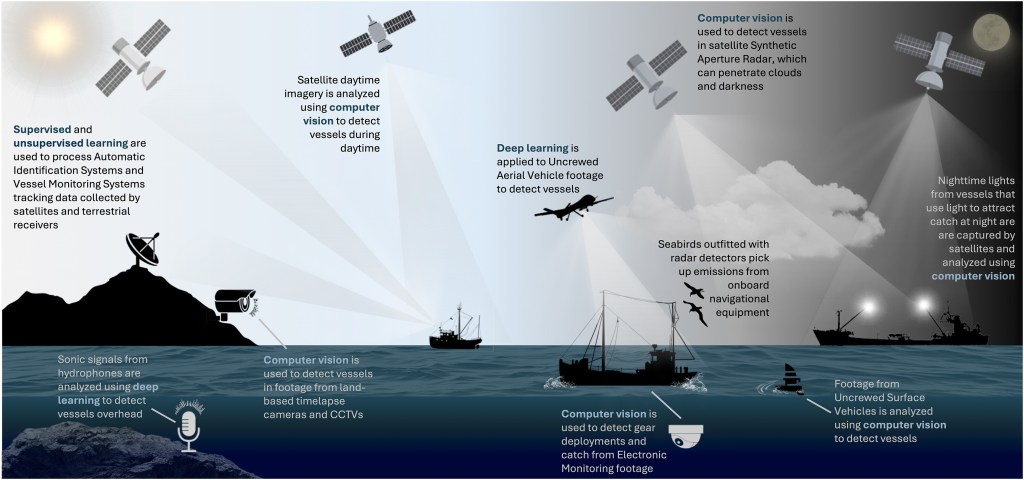
Describing the sheer scale of the global fishing industry necessitates a lot of zeros: 4,900,000 fishing vessels, 40,000,000 million workers, and an annual production of 80,000,000 tonnes of seafood valued at $141,000,000,000. Effective management of the fishing industry requires crunching these big data—while the human mind balks at such a task, the artificial mind does not. Artificial intelligence (AI) is a family of systems that allow computers to simulate human behaviors, such as learning from experience and recognizing visual patterns. This primer explains how AI is used to monitor and surveil fishing vessels from space, shore, and the seafloor and then how it is applied to process this information to meet fisheries management goals, like combating illegal fishing. The exponential rise of AI in fisheries applications over the past decade shows no signs of slowing. We reflect on how the AI of tomorrow may improve fisheries’ sustainability and transparency while emphasizing the sustained need for human oversight in an increasingly automated future.
